
Slika:1776 Rennell - Dury Wall Map of Bihar and Bengal, India - Geographicus - BaharBengal-dury-1776.jpg

Izvorna datoteka (9.106 × 6.000 točk, velikost datoteke: 16,86 MB, MIME-vrsta: image/jpeg)
Spodaj prikazane informacije so s tamkajšnje opisne strani.
Povzetek
| Opozorilo | Nekateri brskalniki bodo sliko v največji ločljivosti morda težko prikazali: slika ima veliko število točk in se morda ne bo naložila pravilno ali pa bo brskalnik zmrznil. |
|---|
| Naslov dela |
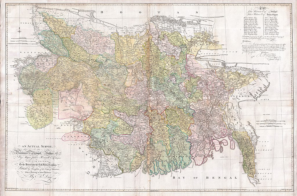
An Actual Survey, of the Provinces of Bengal, Bahar & c. by Major James Rennell Esq. Engineer to the Honorable the East India Company. Published by Permission of the Court of Directors from a Drawing in their Possession by A. Dury. |
|||||||||
| Opis |
English: An altogether spectacular wall sized map of those parts of Bengal and Bihar, India. Follows the course of the Ganges River from Varanasi (Benares) eastward to the Ganges Delta and the Bay of Bengal. Includes Varanasi (Benares), Dacca (Dahka, Bengladesh), and Patna among many other important Indian cities. Bounded on the north by the Himalaya Mountains and the border with Bhutan. One of the first accurate maps of the interior of India. Laid out from primary surveys done by James Rennell, the first modern cartographer to map the interior of India. Notes cities, markets, battlefields, fortresses, roads, rivers, offers political commentary, and features some geographical references. Elaborate title in the lower left quadrant. Upper right quadrant features a dedication and letter of thanks written by Andrew Dury, the publisher, to the board of the East India Company. This is the first edition of this rare map – 1776 – as published by Dury. Later editions were published by Sayer and Bennet and by Laurie and Whittle.
Another high quality digitisation is available at the David Rumsey Historical Map Collection: [1] This map was published by Laurie and Whittle, as mentioned in the description by Geographicus for the 1776 map, in 1794. Regions are demarcated in coloured outlines instead of filled colours. A higher quality digitisation than that of Geographicus. Contains parts that are missing at the central vertical fold in the Geographicus digitisation of the 1776 map. Viewable in online Flash viewer and downloadable in MrSID format. |
|||||||||
| Datum | (dated) | |||||||||
| Vir |
The Bengal Atlas ??, Rennell, James, (1779 first edition)
|
|||||||||
| Ustvarjalec | ||||||||||
| Geotemporalni podatki | ||||||||||
| Omejevalno polje |
|
|||||||||
| Georeferenciranje | ||||||||||
| Arhivski podatki | ||||||||||
| Inventarna številka |
Geographicus link: BaharBengal-dury-1776 |
|||||||||
| Velikost | višina: 39 in (99 cm); širina: 59 in (149,8 cm) | |||||||||

|
Ta slika je bila ovrednotena z merili za dragocene slike in velja za najdragocenejšo sliko v Zbirki na temo: Old maps of Bengal from 1776 by Major James Rennell. Njena nominacija je shranjena na strani Commons:Valued image candidates/1776 Rennell - Dury Wall Map of Bihar and Bengal, India - Geographicus - BaharBengal-dury-1776.jpg. |
Licenca
|
To delo je v javni domeni tudi v državah in na območjih, kjer trajajo avtorske pravice za časa avtorjevega življenja in še 100 let ali manj po tem. Delo je v Združenih državah Amerike v javni domeni, saj je bilo objavljeno (ali registrirano pri Uradu za avtorske pravice ZDA) pred 1. januarjem 1929. | |
| Datoteka je bila prepoznana kot prosta omejitev po avtorskem pravu, vključno z vsemi povezanimi in sorodnimi pravicami. | |
Zgodovina datoteke
Kliknite datum in čas za ogled datoteke, ki je bila takrat naložena.
| Datum in čas | Sličica | Velikost | Uporabnik | Komentar | |
|---|---|---|---|---|---|
| trenutno | 10:39, 17. marec 2011 | | 9.106 × 6.000 (16,86 MB) | BotMultichill | {{subst:User:Multichill/Geographicus |link=http://www.geographicus.com/P/AntiqueMap/BaharBengal-dury-1776 |product_name=1776 Rennell - Dury Wall Map of Bihar and Bengal, India |map_title=An Actual Survey, of the Provinces of Bengal, Bahar & c. by Major Ja |
Uporaba datoteke
Datoteka je del naslednjih 2 strani slovenske Wikipedije (strani drugih projektov niso navedene):
Globalna uporaba datoteke
To datoteko uporabljajo tudi naslednji vikiji:
- Uporaba na ar.wikipedia.org
- Uporaba na as.wikipedia.org
- Uporaba na azb.wikipedia.org
- Uporaba na bn.wikipedia.org
- Uporaba na bn.wikisource.org
- Uporaba na cs.wikipedia.org
- Uporaba na el.wikipedia.org
- Uporaba na en.wikipedia.org
- Uporaba na es.wikipedia.org
- Uporaba na fa.wikipedia.org
- Uporaba na fr.wikipedia.org
- Uporaba na hi.wikipedia.org
- Uporaba na ja.wikipedia.org
- Uporaba na ko.wikipedia.org
- Uporaba na ml.wikipedia.org
- Uporaba na mt.wikipedia.org
- Uporaba na ne.wikipedia.org
- Uporaba na nl.wikipedia.org
- Uporaba na pnb.wikipedia.org
- Uporaba na sa.wikipedia.org
Oglejte si globalno uporabo te datoteke.